Waste & landfill
Nubarashen landfill, recycling
Almost all of Yerevan's waste goes unsorted to the Nubarashen dump: 52 hectares with no bottom lining, which burned in 2020, 2021, 2023, 2024 and 2025. A new landfill has been promised since 2015 and is still not built; in 2026 the city picked a consortium to build a waste-processing plant.
Facts checked
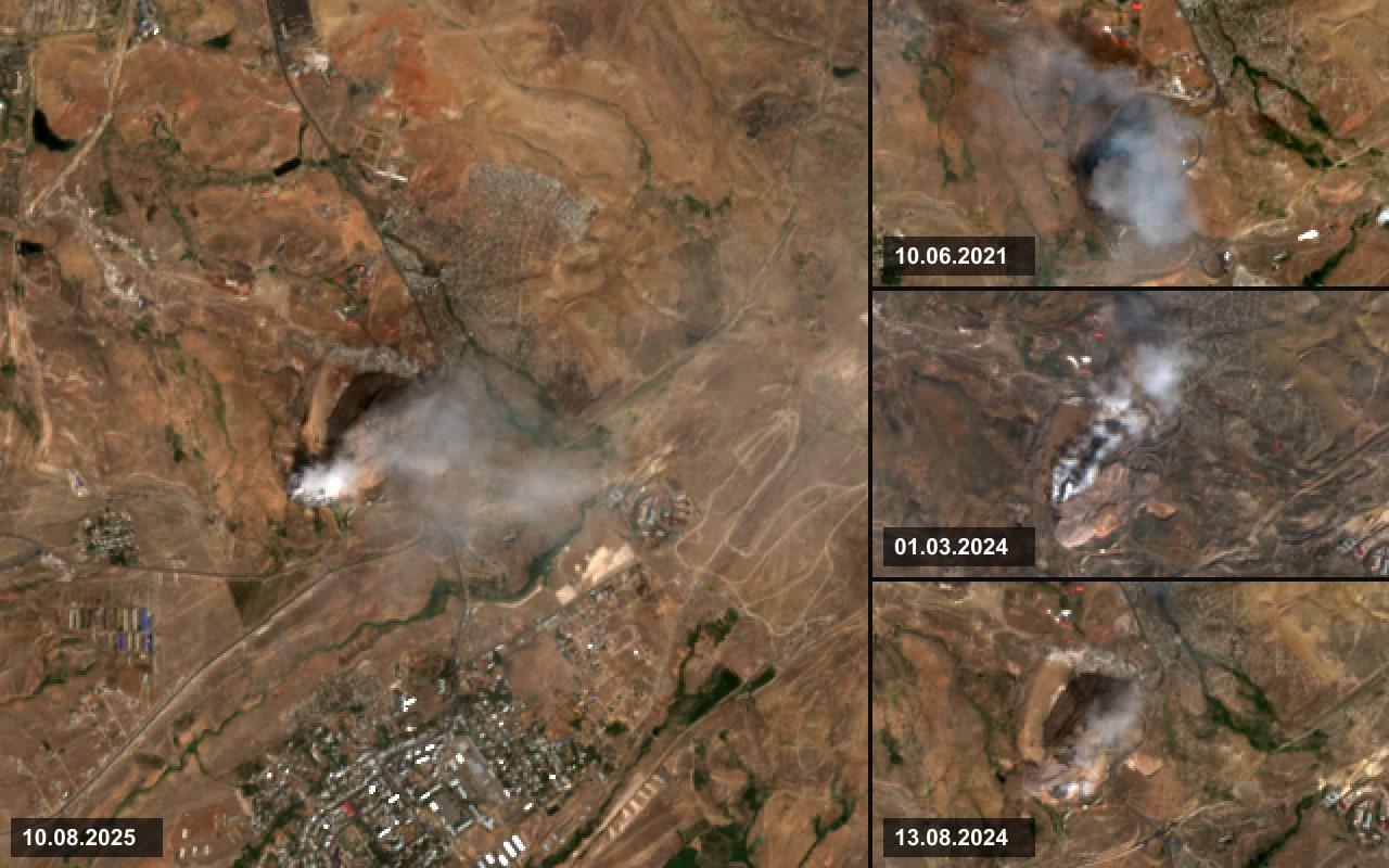
Smoke over the dump on days Sentinel-2 passed over a fire: 10 August 2025, 10 June 2021, and 1 March and 13 August 2024.
Imagery: Contains modified Copernicus Sentinel data 2021–2025 · Copernicus · Copernicus Sentinel data terms
How it began
Before. The dump was opened on the edge of Nubarashen without a permit, and for decades all of the city's waste went there unsorted, onto bare ground. Gas capture arrived in 2009 and covers 7 of the 52 hectares.
What changed. Fires nearly every summer and ten years of a new-landfill project that never happened made the dump what ecologists call a 'toxic bomb'.
From noxious fumes to empty pledges: Yerevan's long struggle with its 'toxic bomb' dumpsite — OC Media, September 11, 2025
How to Solve Nubarashen Landfill File Problem — EcoLur, November 7, 2025
Timeline
- Origin
The city starts dumping its waste on the edge of Nubarashen
Sources disagree on the date: OC Media and Azatutyun say the 1950s, the 2015 impact assessment for the EIB and EVN Report say the early 1960s. The dump had no permit, and it still has no bottom lining.
Yerevan Solid Waste Project: Environmental and Social Impact Assessment — European Investment Bank, May 19, 2015
Resolving the Unresolved Issue of Garbage — EVN Report, October 31, 2023
- Decision
Japan's Shimizu starts capturing landfill gas on part of the dump
City Hall and Shimizu Corporation launched a project to collect and burn methane. It covers 7-8 of the 52 hectares; the rest of the dump has no gas collection.
- Decision
Waste collection passes to the Lebanese company Sanitek
Sanitek S.A.R.L. won an international tender and started work with a stated investment of about €10M in trucks and bins. Its 2013 contract covered the western districts (Kentron, Malatia-Sebastia, Shengavit, Davtashen, Ajapnyak); a 2015 contract added the eastern ones.
- Decision
The EBRD loan for a new landfill is signed: €24M
The Finance Ministry, City Hall and the EBRD signed the agreements: an €8M EBRD loan, an €8M EIB credit line and an €8M EU grant. The plan was a ~30 ha sanitary landfill next door with a 28-year life. Closing the old dump was an EBRD condition but not part of the project.
- Decision
A €2M grant to close the old dump brings the budget to €26M
Armenia signed a €2M grant from the E5P fund with the EIB for the project's second component, isolating the existing dump.
- Decision
The government extends the loan: 'the landfill will be ready in 2021'
At a government session the EBRD agreement was extended, with a promise to build a new landfill and close the Nubarashen and Ajapnyak dumps.
- Decision
The city sets up its own waste-collection service
The Council of Elders set up the municipal institution Yerevan Waste Removal and Sanitary Cleaning. By 2025 it ran 41 garbage trucks and 11,400 bins at 4,165 sites.
- Legal
Sanitek starts a pre-arbitration procedure against the government
By then the city had already fined the company, and a tax case had been opened against it.
- Decision
Mayor Marutyan unilaterally terminates the Sanitek contracts
According to the mayor, the company had collected waste poorly since 2017, the failures became widespread in 2018, and on 29 August 2019 it stopped work altogether.
- Development
Damage to the city put at ~5.31 billion dram, no suspects
Investigators put the damage to Yerevan in the Sanitek case at about 5.31 billion dram, plus 580 million dram in unpaid taxes. At the time there were no suspects and nothing had been recovered.
- Fire
The dump burns for more than a week
LossThe fire broke out on 7 September. On 10 September the rescue service counted three burning areas, the largest about 4.5 ha; on 15 September firefighting was still going on.
- Legal
Sanitek files an ICSID arbitration claim against Armenia
The company and its owners claimed about $36M under Armenia's investment treaties with Lebanon and Canada. ICSID registered the case on 6 April 2021.
- Fire
Fire at the dump
The day also appears in the NASA satellite data below.
- Development
The Shimizu agreement expires and an offer to extend gas capture is turned down
The station was handed over free of charge to the landfill operator. Shimizu had offered to extend gas collection across the whole site and generate electricity from it; the offer was rejected.
- Legal
Former deputy mayor Vahe Nikoyan is arrested
OngoingHe is accused of authorizing payment of three billion dram ($7.6M) to Sanitek for services it did not provide. Sanitek meanwhile rented three properties from his father. In September 2023 the case went to court on abuse-of-power and bribery charges; in October 2024 witnesses were still being heard.
- Fire
The dump burns for ten days
LossThe fire covered about 4 ha and was put out only on 27 May, after 2,300 truckloads of soil. In the satellite data, 18 May is the strongest reading before 2025.
- Fire
Three more fires over the summer
LossThe dump caught fire on 13 June, 21 July and 25 July; the last fire covered about 5,000 m² and was contained the next day.
- Fire
A fire in early March
- Development
City Hall drops the new-landfill project
LossMayor Tigran Avinyan: 'If a project is not implemented for 10 years, it is no longer an implemented project.' His reason: 'Those financial means are not available'; he promised to do it with World Bank partners within 3-4 years. Ecologist Inga Zarafyan relayed a different municipal account, that no company entered the tender. City Hall later described it as termination by mutual agreement.
Tigran Avinyan · Yerevan Municipality
- Fire
3 of the 52 hectares burn
LossPutting it out took several days, about 150 truckloads of soil and 500 tonnes of water. Satellites recorded the fire as early as 11 August UTC.
- Fire
Nine days and 22,000 tonnes of water
LossAbout 5 ha burned. It took 22,035 tonnes of water and 2,450 truckloads of soil, with 430 rescuers; by 17 August the dump was fully covered. Official readings for the first ten days of August showed dust in Yerevan at 1.01-2.1 times the maximum permissible concentration. The operator's acting director Vahe Vardapetyan blamed glass fragments in 40-degree heat and methane under the waste. On 9 August satellites recorded the strongest reading on record.
Yerevan Districts Affected By Smoke After Landfill Blaze — Azatutyun (RFE/RL), August 12, 2025
Tigran Avinyan: the two-stage tender for a new waste-processing plant must take place by year-end; we can no longer delay — Мэрия Еревана, August 18, 2025
- Decision
The mayor orders a plant tender by year-end
Tigran Avinyan: 'Either the bidding takes place by yearend, or I make the appropriate personnel decisions.'
- Civic action
Eight organizations demand the dump's closure and a health study
The statement makes seven demands: public hearings, a tender for sorting and recycling, closing and conserving the dump, enforcing the ban on child labor, protective equipment for waste pickers, a health study and public monitoring. The authors say dozens of people, minors among them, sort waste at the dump without protection.
- Fire
A small fire, about 700 m²
- Fire
Another fire, and the mayor suggests arson
LossThe dump caught fire on the night of 9-10 October and was contained on the 12th, after about 1,400 tonnes of water and 900 truckloads of soil. Dust ran 1.1-4.7 times above the permitted limit. The mayor suggested the fire may have been set deliberately.
- Decision
City Hall ends the contract with the dump's private operator
After the October fire Mayor Avinyan said City Hall had ended the contract for running the dump with a private company and taken it over; video surveillance is being installed and vehicle entry restricted. As late as April 2025 the operator was the private company Erebuni Maqrutyun. Creating the Yerevan City New Landfill company was on the Council of Elders' agenda on 25 November 2015, when the city was preparing the new-landfill project.
Tigran Avinyan · Yerevan Municipality
Yerevan's mayor names long-term and short-term solutions to the Nubarashen dump problem — АРКА, October 23, 2025
- Development
The city returns to a new landfill and closing the old one
OngoingCity Hall put a new sanitary landfill at $13.4M and closing Nubarashen at $15.6M, and applied to the World Bank, the EBRD and the Asian Development Bank. The dump is now run by the municipal company Nor Aghbavayr. A consultant tender was announced on 12 December; the city targeted construction for autumn 2026, itself calling that timeline 'extremely ambitious'.
- Decision
The waste-processing plant tender is announced
An open two-stage tender to build and operate a plant processing mixed municipal solid waste; bids due 27 March 2026. Under the model contract the investor builds the plant at its own expense on 5 hectares at 30/2 Nubarashen Highway: the land comes as a 23-year building right, although the plant must run for at least 30 to 35 years. The city undertakes to deliver no less than 800 tonnes of unsorted waste a day; up to a fifth of the intake may be waste already lying on the dump. The investor puts a City Hall nominee on its governing bodies, hires at least 30% local staff and hands the equipment to the city free of charge when the term ends. The investment amount is left blank in the model, and it contains no fee for accepting waste.
- Fire
Tires burn next to the dump, and an explosion injures two
A large fire broke out on a plot of discarded tires next to the dump and was put out by two crews. That evening, by preliminary reports, gas that had built up exploded when a light was switched on in a toilet by the guard post. The dump's director and a worker were taken to hospital, one of them in extremely serious condition.
- Legal
The ICSID tribunal rejects Sanitek's claim in full
WinThe tribunal (Laurence Shore, Bernard Hanotiau, Pierre Mayer) unanimously ruled for Armenia. According to the government, it found the company had not performed the contract despite being paid, and that the termination was justified.
- Decision
A Chinese-Arab-Armenian consortium wins the plant tender
OngoingOf four bidders, two reached the second stage. The winner is a consortium of China Western Power Industrial, MASAR and the Armenian company Masshtab Consulting. The plant is for 600 tonnes a day over 30-35 years, on 5 ha provided by the city. The financial terms have not been published, and journalists were refused the tender committee's minutes on the grounds that they had been 'archived'.
Where it is

In red: the outline in OpenStreetMap
- Center
- 40.1073, 44.5484
- Outline area
- 40.7 ha. This is the area of the shape drawn in OpenStreetMap, not a survey of the dump itself.
The dump from orbit
The same patch of ground in the same frame, one cloud-free summer image per frame. The yellow line is the same on every frame, so anything that crosses it shows at once.

Area of the Nubarashen landfill by year
On every frame where the dump's edge can be seen, it was outlined by an AI model, Claude; no person corrected the outlines. The area takes in everything the dump occupies: open waste, sections covered with soil, and the embankments at its edges. Access roads are left out. Each year's outline is shown on its frame in the slider above.
Area of the Nubarashen landfill by year
The bar at each point shows how much the area changes if the line is moved one pixel of the frame outward or inward along the whole edge.
A hollow circle is an image taken more than 15° off vertical: on it, slopes are displaced against ravine floors, and the error can exceed the bar.
The dashed line is the dump's outline in OpenStreetMap, for comparison: it runs outside the visible edge and takes in the slopes around it.
The images, outlines, area tables and the code that recomputes them are published as an open dataset: github.com/yerevan-for-people/nubarashen-landfill-satellite
Sources: SPOT 1–4, SPOT 5, Sentinel-2, OpenStreetMap
yfp.am/en/topics/waste#footprint-growth-chart
 Yerevan for People
All measurements (31)
| Image date | Satellite | Area, ha |
|---|---|---|
| August 6, 1986 | SPOT 1–4 | 12.0 ± 1.3 |
| July 28, 1989 | SPOT 1–4 | 15.9 ± 1.6 |
| September 4, 1990 | SPOT 1–4 | 16.1 ± 1.5 |
| September 29, 1991 | SPOT 1–4 | 15.5 ± 1.5 |
| September 6, 1992 | SPOT 1–4 | 19.2 ± 1.7 |
| August 17, 1994 | SPOT 1–4 | 19.6 ± 1.7 |
| August 26, 1997 | SPOT 1–4 | 21.7 ± 1.8 |
| July 2, 1999 | SPOT 1–4 | 21.9 ± 1.8 |
| July 26, 2000 | SPOT 1–4 | 21.7 ± 1.8 |
| August 19, 2002 | SPOT 1–4(oblique) | 22.3 ± 1.8 |
| September 6, 2003 | SPOT 5 | 22.9 ± 0.9 |
| June 18, 2004 | SPOT 5 | 22.0 ± 0.9 |
| September 23, 2005 | SPOT 5(oblique) | 21.9 ± 0.9 |
| August 12, 2006 | SPOT 5 | 20.6 ± 0.9 |
| August 1, 2007 | SPOT 5 | 23.7 ± 1.0 |
| July 12, 2010 | SPOT 5 | 23.9 ± 1.0 |
| July 11, 2011 | SPOT 5 | 24.2 ± 1.0 |
| June 28, 2012 | SPOT 5(oblique) | 25.7 ± 1.0 |
| June 2, 2013 | SPOT 5 | 26.7 ± 1.0 |
| August 22, 2014 | SPOT 5(oblique) | 26.6 ± 1.0 |
| August 25, 2016 | Sentinel-2 | 27.8 ± 2.0 |
| September 9, 2017 | Sentinel-2 | 26.9 ± 2.0 |
| September 14, 2018 | Sentinel-2 | 27.7 ± 2.0 |
| September 24, 2019 | Sentinel-2 | 24.7 ± 1.9 |
| September 18, 2020 | Sentinel-2 | 25.0 ± 1.9 |
| September 28, 2021 | Sentinel-2 | 26.6 ± 2.0 |
| September 28, 2022 | Sentinel-2 | 28.0 ± 2.0 |
| August 14, 2023 | Sentinel-2 | 27.3 ± 2.0 |
| September 2, 2024 | Sentinel-2 | 28.8 ± 2.1 |
| August 18, 2025 | Sentinel-2 | 31.2 ± 2.2 |
| August 23, 2026 | Sentinel-2 | 32.8 ± 2.4 |
SPOT 1–4, black and white 1986-2002
1986August 6, 1986 
1989July 28, 1989 
1990September 4, 1990 
1991September 29, 1991 
1992September 6, 1992 
1994August 17, 1994 
1997August 26, 1997 
1999July 2, 1999 
2000July 26, 2000 
2002August 19, 2002 tilted 15°
The first four SPOT satellites imaged from 1986. For each year the archive holds a summer image of the site, of those not covered in cloud the one taken closest to vertical was chosen and aligned to the 2016 Sentinel-2 frame the same way as the SPOT 5 images. Years with no image are skipped. Contrast is stretched for each frame separately. One pixel is 10 m.
SPOT 1–4 © CNES 1986-2002. Spot World Heritage
SPOT 5, black and white 2003-2014

2003September 6, 2003 
2004June 18, 2004 
2005September 23, 2005 tilted 24°

2006August 12, 2006 
2007August 1, 2007 
2010July 12, 2010 
2011July 11, 2011 
2012June 28, 2012 tilted 24°

2013June 2, 2013 
2014August 22, 2014 tilted 30°
For each year, of the summer black-and-white SPOT 5 images not covered in cloud, the one taken closest to vertical was chosen. The CNES archive delivers them without map placement, so each was aligned to the 2016 Sentinel-2 frame by the roads, ravines and streets that have not moved since; the dump itself takes no part in the alignment. Where a year had no vertical image, an oblique one was used: on it hills and ravines are displaced against each other by tens of meters, and the frame is marked tilted. Contrast is stretched for each frame separately. One pixel is 5 m.
SPOT 5 © CNES 2003-2014. Spot World Heritage
Sentinel-2, every summer 2016-2026

2016August 25, 2016 
2017September 9, 2017 
2018September 14, 2018 
2019September 24, 2019 
2020September 18, 2020 
2021September 28, 2021 
2022September 28, 2022 
2023August 14, 2023 
2024September 2, 2024 
2025August 18, 2025 
2026August 23, 2026
For each year, the July to September image with the least cloud over its whole 100 × 100 km tile was chosen; the date under each frame is the day it was taken. Natural color, one pixel is 10 m.
Contains modified Copernicus Sentinel data 2016-2026. Copernicus Data Space Ecosystem
Fires in satellite data
How many days a year NASA satellites recorded a heat anomaly over the dump. A bar counts days, not fires: one fire burning for a week shows up as several days.
- Days with a detection
- 39
- Of them inside the outline
- 27
- Strongest reading
- 53 MWAugust 9, 2025
Fires at the Nubarashen landfill in satellite data
This is a floor. A fire under cloud, between overpasses or smoldering below the sensor's threshold leaves no record. Until 2012 only MODIS was flying, with a 1 km pixel that sees only large fires; VIIRS joined in 2012 and a second VIIRS satellite in 2018. So the early years do not compare with the later ones.
The latest months are NASA's near-real-time data; once reprocessed, individual points may shift or drop out.
Sources: NASA FIRMS, OpenStreetMap
yfp.am/en/topics/waste#satellite-fires-chart
Yerevan for PeopleEvery day with a detection (39)
| Date | Detections | Strongest reading, MW | Sensors |
|---|---|---|---|
| August 6, 2010(only within 500 m of the outline) | 1 | 13.8 | MODIS |
| May 2, 2013 | 1 | 0.6 | VIIRS |
| May 3, 2013(only within 500 m of the outline) | 1 | 1.6 | VIIRS |
| June 16, 2013 | 1 | 0.4 | VIIRS |
| June 19, 2014(only within 500 m of the outline) | 1 | 5.5 | MODIS |
| September 26, 2014 | 2 | 4.4 | VIIRS |
| July 19, 2015 | 1 | 0.5 | VIIRS |
| July 24, 2015(only within 500 m of the outline) | 1 | 0.5 | VIIRS |
| August 2, 2015 | 6 | 29.0 | MODIS, VIIRS |
| August 6, 2015 | 6 | 3.8 | VIIRS |
| August 19, 2015 | 1 | 1.0 | VIIRS |
| August 20, 2015 | 2 | 1.1 | VIIRS |
| September 28, 2015 | 1 | 3.5 | VIIRS |
| August 4, 2016(only within 500 m of the outline) | 1 | 0.8 | VIIRS |
| July 23, 2019(only within 500 m of the outline) | 1 | 3.3 | VIIRS |
| September 10, 2020 | 2 | 5.5 | VIIRS |
| September 11, 2020 | 2 | 0.7 | VIIRS |
| October 13, 2020(only within 500 m of the outline) | 1 | 0.7 | VIIRS |
| June 8, 2021 | 1 | 12.2 | MODIS |
| June 26, 2021 | 2 | 3.2 | VIIRS |
| May 10, 2022 | 1 | 2.0 | VIIRS |
| May 18, 2023 | 7 | 44.3 | MODIS, VIIRS |
| May 19, 2023 | 1 | 2.5 | VIIRS |
| August 6, 2023(only within 500 m of the outline) | 1 | 6.5 | VIIRS |
| August 9, 2023 | 4 | 3.9 | VIIRS |
| February 29, 2024 | 2 | 2.6 | VIIRS |
| April 25, 2024(only within 500 m of the outline) | 2 | 2.3 | VIIRS |
| August 11, 2024 | 4 | 3.0 | VIIRS |
| August 12, 2024 | 1 | 0.8 | VIIRS |
| August 15, 2024 | 1 | 4.1 | VIIRS |
| September 5, 2024(only within 500 m of the outline) | 1 | 0.6 | VIIRS |
| June 9, 2025(only within 500 m of the outline) | 1 | 0.8 | VIIRS |
| July 28, 2025 | 1 | 9.7 | VIIRS |
| August 8, 2025 | 12 | 37.0 | VIIRS |
| August 9, 2025 | 4 | 53.4 | MODIS, VIIRS |
| August 10, 2025 | 1 | 2.6 | VIIRS |
| August 11, 2025(only within 500 m of the outline) | 1 | 0.7 | VIIRS |
| September 15, 2025 | 1 | 2.4 | VIIRS |
| October 10, 2025 | 11 | 26.9 | MODIS, VIIRS |
NASA FIRMS detections whose pixel center lies inside the landfill outline from OpenStreetMap or within 500 m of it. A VIIRS pixel is 375 m across and a MODIS one 1 km, so a point at the edge cannot be pinned on the dump with certainty.
Data: NASA FIRMS (MODIS, VIIRS S-NPP, VIIRS NOAA-20). Outline: © OpenStreetMap contributors, ODbL. Retrieved October 9, 2026. openstreetmap.org/copyright
Promises & what happened
- Yerevan MunicipalityBroken
«By 2018 the Nubarashen dump in its present form will most likely no longer exist.»
The dump is still operating in 2026; closing it is costed at $15.6M and unfunded.
- Vahe Nikoyan — Deputy Mayor of Yerevan (under Taron Margaryan)Broken
«The project's third component will be waste recycling in a private partnership.»
The project was dropped in 2024. Separately collected glass, plastic and paper have made up 0.11% of all waste since 2020.
- Vahe Nikoyan — Deputy Mayor of Yerevan (under Taron Margaryan)Broken
«The second component is building a new landfill to international criteria and isolating the existing Nubarashen and Ajapnyak dumps.»
- Government of ArmeniaBroken
«The landfill will be ready in 2021; the Nubarashen and Ajapnyak dumps will be closed.»
- Tigran Avinyan — Mayor of YerevanPending
«Building a new landfill at another site will take five years.»
Said in a Facebook post in May 2023 that we have only in FIP's paraphrase. A year later the project in question was dropped.
- Yerevan MunicipalityBroken
«Construction of the new landfill will begin in 2024 (Yerevan's 2024 development plan).»
Five months later the project was dropped.
- Tigran Avinyan — Mayor of YerevanPending
«Most likely we will implement this program with World Bank partners in the next 3-4 years.»
By December 2025 there is no World Bank project; City Hall names the EBRD as its main partner.
- Tigran Avinyan — Mayor of YerevanKept
«Either the plant tender takes place by year-end, or there will be personnel decisions.»
The tender was announced on 26 December 2025.
- Yerevan MunicipalityPending
«We expect construction of the new landfill to begin in autumn 2026.»
City Hall itself called this timeline 'extremely ambitious'.
Claims & fact-check
- Yerevan MunicipalityDisputed
«About 600 tonnes of waste a day, about 200,000 tonnes a year, go to Nubarashen (City Hall's feasibility studies).»
In fact: The figure comes from a study done for the EBRD (final report, July 2023) and is quoted in City Hall's tender documents. The same documents call an estimate of about 450,000 tonnes a year 'the most reliable' and state that no precise data exist. The dump has no weighbridge: the city's 2025-2029 waste management program says so. The city undertakes to deliver at least 800 tonnes a day to the plant.
Said: September 30, 2026 · Azatutyun (RFE/RL)Checked: October 13, 2026
- Yerevan MunicipalityDisputed
«The EBRD program was shut down because no company would take part in the tender (as relayed by Inga Zarafyan, EcoLur).»
In fact: In July 2024 the mayor gave a different reason: 'Those financial means are not available.' In December 2025 City Hall called it termination by mutual agreement.
Checked: October 9, 2026
Red flags
- Conflict of interest
The deputy mayor who, according to the charges, authorized payments to Sanitek for services not provided was tied to the company: it rented three properties from his father.
- Non-disclosure
The financial terms of the waste-plant contract are unpublished, and journalists were refused the tender committee's minutes because they had been 'archived'.
- Conflict of interest
In February 2026 Armenia nominated to its ICSID panel of arbitrators a lawyer who had been on Sanitek's legal team in the case against Armenia.
Litigation
- International arbitrationDecidedClaim rejectedCase no. ICSID ARB/21/17
Sanitek Armeniav.Government of Armenia
Sanitek and its owners' claim for about $36M in compensation over the termination of the waste-collection contracts.
Filed: March 11, 2021Decided: May 22, 2026The tribunal unanimously rejected every claim.
- Anti-Corruption CourtIn hearingsCase no. ՀԿԴ/0200/01/23
Prosecutor's Officev.Vahe Nikoyan
The criminal case against former deputy mayor Vahe Nikoyan: according to the charges, he passed bids from companies that did not meet the waste-collection tenders' criteria and approved payment for their services without checking the acceptance reports.
Filed: September 11, 2023As of 13 October 2026 there is no verdict. Fifty-four hearings have been held, the last on 23 June 2026; the next three did not take place, and another is set for 24 November 2026.
Money
- 26 million EURContract value
Financing for a new landfill and isolating Nubarashen: an €8M EBRD loan, an €8M EIB credit line, an €8M EU grant (2015) and a €2M E5P grant (2017). The project was dropped in 2024.
December 11, 2015EBRD, Yerevan Municipality - 13.4 million USDCost estimate
City Hall's estimate for a new sanitary landfill.
December 9, 2025Yerevan Municipality - 15.6 million USDCost estimate
City Hall's estimate for closing the Nubarashen dump.
December 9, 2025Yerevan Municipality
Connections
What we don't know yet
- How much waste actually reaches the dump. It has no weighbridge, and every figure is an estimate: from 200 to 450 thousand tonnes a year in City Hall's own documents, up to 600 thousand in the press.
- Whether the dump today holds a permit or a positive environmental review. None of the sources names such a document, and the Council of Elders wrote in its 2019-2023 development program that the dump meets no technical, environmental or sanitary standard.
- How the fires affect the health of ~15,000 people in Nubarashen and ~120,000 in Erebuni. We found no study of illness rates: the 2015 assessment done for the EIB says outright that the dump's effect was never studied on its own, and eight organizations demanded such a study in 2025. During the fires, judging by the bulletins we found, dust, nitrogen dioxide and sulfur dioxide were measured; we found no data on dioxins or heavy metals near the dump.
- Where the waste beyond the plant's capacity will go, and what happens to the people who sort waste on the dump today. Under the tender documents the plant is designed for at least 600 tonnes a day, the city undertakes to deliver no less than 800, what is left after processing goes to a landfill, and a new sanitary landfill is 'envisaged' next door: the documents say nothing more about it. The documents and the model contract do not mention the sorters at all.
Sources
- Yerevan Solid Waste Project: Environmental and Social Impact AssessmentEuropean Investment Bankarchive · October 4, 2024
- A Grant Agreement was SignedМинистерство финансов Арменииarchive · August 14, 2025
- Yerevan five-year development program for 2019-2023Совет старейшин Ереванаarchive · October 2, 2022
- Yerevan municipal waste management program for 2025-2029Совет старейшин Ереванаarchive · November 2, 2026